bootcamp: “ ”, the Bellman cried!
the bellman’s map (revised)
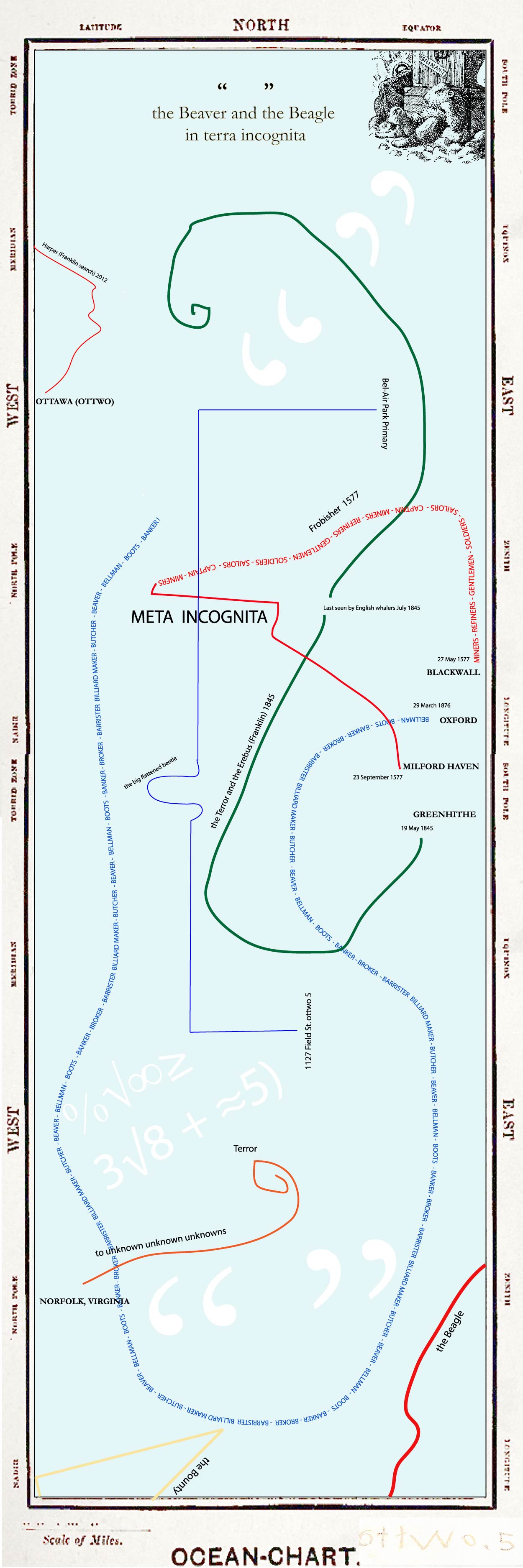
The Beaver and the Beagle in terra incognita.
This map is a continuation of my look at The Hunting of the Snark (1874) started in the Markdown boot camp. A narrative is a kind of a map, a map of a journey through time. So The Hunting is already a map or a certain kind–a map with a certain end (a jovial evasion of oblivion by a logician). And it also contains within it a literal (blank) map as a clue, or a decoy or an amusement. My new map makes a layering of one narrative on top of another to add cross-dimension to the linearity of narrative. This allows me to situate some juxtapositions without asserting them as fact in an expository way. The layering here begins with thinking about the terra incognita (unknown land) to which the Bellman’s map seems to refer, those blank spaces on the early maps of empire not yet explored or assayed. By Carroll’s C19, the apex of empire, very few of these blanks remained in the space/time of Victorian cartographers. To the map of The Hunting I add a fragment of the journey’s of Martin Frobisher, who searched and mapped Baffin Island on behalf of the English crown. In 1577 he returned to London from Baffin with tons of ore (mistakenly thought to be gold) and three kidnapped Inuit (mistakenly thought to be cannibals). What you desire most comes along with what you fear most (gold with cannibals, snarks with boojums). Queen Elizabeth named the new-claimed territory meta incognita (the unknown limits). To this layer is added trajectory fragments of the Franklin expedition, which departed England in 1845 and became lost (thirty years before The Hunting). Searches for Franklin’s lost ships and men continued sporadically into the 1870’s. Much commercial exploration in the arctic was carried out under this label (and it goes on, witness Harper’s search). To this is added a last layer which is my own pre-literate trajectory through The Hunting by crayon and my first trajectories through my childhood neighborhood.
Is this map accurate to the data? I think not. Does it have an intentional or specific communication goal. No. Are the juxtapositions intentional? Yes. Is the intention for a fixed result or reading on the part of the reader? No. Does it have value as a critical tool? Perhaps. If I am a designer engaged to create a visualization of a certain communicable position I am making a representation of that position or ideology. If I do my job professionally the facts and the ideas (and the ideology) will all line up. If, however, I mimic such a rationalistic representation as a gambit to juxtapose some disparate information, facts, views, conjectures without knowing the specific outcome for individual viewers, then I might be mis-designing with purpose. In this case I have made some choices about what to put in this mix, but without premeditation about what people should conclude. In other words, the juxtaposition comes before the conclusion as a kind of pre-thought. (No doubt conclusions seep in along the way.) So the designer or the social scientist (or the explorer) is looking for things to ‘appear’ as nodes in the data according to the map’s logic. Hunting for the Snark, so to speak. But another question is what might ‘disappear’, sliding into the cracks of this method.
